பைக்காரா லோகோ

நீலகிரி நடைப்பயணப் பாதைகள்Nilgiris trekking trails

நீலகிரி நடைப்பயணப் பாதைகள் — பைக்காரா அருகே நடை மற்றும் மலைப் பயணம்Nilgiris trekking trails — walks and hikes near Pykara

நீலகிரியில் பல மலை நடைப் பாதைகள் உள்ளன. பைக்காரா அருகில் பைன் காடு மற்றும் வென்லாக் டவுன்ஸ் போன்ற தட்டையான பகுதிகள் நடைக்கு ஏற்றது. அனுமதி மற்றும் வழிகாட்டியை உறுதி செய்யவும்.The Nilgiris have many hilly trails. Near Pykara, pine forest and Wenlock Downs offer flatter walking. Confirm permission and a guide.

Google Maps-இல் பார்க்க ↗View on Google Maps ↗புதுப்பிக்கப்பட்டது: 6 November 2026Last reviewed: 6 November 2026

இந்த இடத்தை அறியுங்கள்Explore the destination

நீலகிரி நடைப்பயணப் பாதைகள் – கண்டறியுங்கள்Discover Nilgiris trekking trails

நீலகிரியில் மலையேற்றம் என்பது ஒரே இடமல்ல; பல்வேறு நிலப்பரப்பு, தூரம், அனுமதிக்கப்பட்ட பாதைகளில் தேர்வு செய்வதாகும். சோலைக் காடுகள், புல்வெளிகள், மலைச் சரிவுகள் ஆகியவை நடைபயணத்தில் தெரியும்.Trekking in the Nilgiris is not one fixed attraction: it is a choice among landscapes, distances and permitted routes. Walks can reveal the region’s distinctive shola forest and grassland pattern, mountain slopes and changing weather. A good experience begins with selecting a route appropriate for fitness and access rules.

அனுமதிக்கப்பட்ட நடைபயணத்தில் தாவரங்கள், நில அமைப்பு மற்றும் காலநிலையின் மாற்றங்களைக் காணலாம்.A guided or officially open walk can reveal changes in vegetation, terrain and mountain weather.

Nilgiris trekking trails
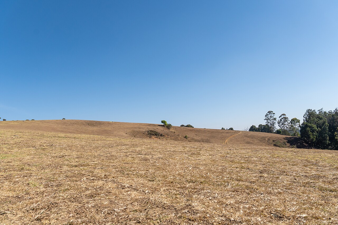
Rainer Halama / Wikimedia Commons — Nilgiri Biosphere Reserve–Wenlock Downs (regional landscape)

Visit planning

பயண ஆலோசனைகள்Visit tips

உடல்தகுதிக்கு ஏற்ற அனுமதிக்கப்பட்ட பாதையைத் தேர்ந்து, தேவைப்பட்டால் வழிகாட்டியை ஏற்பாடு செய்யவும்.Choose an officially permitted trail matched to your fitness and arrange a guide wherever required.

Highlights

முக்கிய அம்சங்கள்Scenic highlights

சோலைக் காடு–புல்வெளி நிலப்பரப்பு, உயர வேறுபாடு மற்றும் நீலகிரி மலைச் சூழியல்.Shola-grassland mosaics, varied elevation and the Nilgiris’ distinctive mountain ecology.

இந்த இடத்தைப் பற்றிAbout the attraction

நீலகிரி நடைப்பயணப் பாதைகள் – வரலாறும் பின்னணியும்About Nilgiris trekking trails

நீலகிரியின் உயர்நிலம் சுற்றுச்சூழல் முக்கியத்துவம் வாய்ந்தது. பாதுகாக்கப்பட்ட காடுகளில் எல்லா இடங்களிலும் சுயமாக நடக்க முடியாது; குறிப்பிட்ட பாதை மற்றும் அனுமதிகளைப் பின்பற்ற வேண்டும்.The Nilgiri highlands are ecologically sensitive, with protected forests and habitats that are not open to casual wandering. Responsible trekking therefore depends on the specific route, local permissions and guidance. The landscape should be understood as a living environment, not simply an outdoor backdrop.

மலையேற்றப் பாதைகள் என்பது ஒரே நுழைவுக் கட்டணம் அல்லது நேரம் கொண்ட தனி சுற்றுலா இடம் அல்ல.“Trekking trails” describes multiple routes rather than one named attraction with a single ticket gate or opening schedule.

அடிப்படைத் தகவல்At a glance

அடிப்படைத் தகவல் புள்ளிவிவரம்Quick facts

சிறந்த காலம்Best time
செப்டம்பர்–மே (பருவமழைக்குப் பிறகு)September–May (after the monsoon)
நிலைTerrain
மலைப்பகுதி; சில தட்டையான பகுதிகள்Hilly terrain; some flat sections
அனுமதிPermit
பாதுகாக்கப்பட்ட பகுதிகளில் காட்டுத் துறை அனுமதி தேவைForest-department permit needed in protected areas
இருப்பிடம்Location
பைக்காரா மற்றும் ஊட்டி சுற்றுப்புறங்கள்Around Pykara and Ooty

பயண நேரம்Plan your visit

திறப்பு நேரம்Opening hours

இடம் மற்றும் பருவத்தைப் பொறுத்து நுழைவு நேரம் மாறலாம். அன்றைய நுழைவு நேரத்தை வரைபடப் பட்டியல் அல்லது உள்ளூர் அறிவிப்பில் பார்க்கவும்.Visiting windows vary by location and season. See the attraction’s map listing or entrance notice when planning your day.

இடத்தைப் பார்க்க ↗View location ↗

செலவுகள்Admission

நுழைவுக் கட்டணம்Ticket prices

நுழைவு, வாகன நிறுத்தம், வழிகாட்டி அல்லது பயண முன்பதிவு ஆகியவை இடத்துக்கு ஏற்ப வேறுபடும். பயணத்திற்கு முன் பொருந்தும் கட்டண வகையைத் தேர்வு செய்யவும்.Entry, parking, guided visits and advance bookings are separate considerations. Choose the services relevant to your itinerary and check the posted rates.

செல்லும் வழிGetting there

போக்குவரத்துTransport options

ஊட்டியிலிருந்து சாலை வழி, உள்ளூர் வாகனம் அல்லது கிடைக்கும் பொதுப் போக்குவரத்தைப் பயன்படுத்தலாம். தொலைதூர வனப் பகுதிகளில் முன் அனுமதி தேவைப்படலாம்.Travel from Ooty by the suitable road route, local vehicle or available public transport. Remote forest areas may require an arranged excursion or access permit.

இடத்தின் சிறப்புDiscover the appeal

இயற்கை, நில அமைப்பு மற்றும் அனுபவம்Landscape, heritage & core experiences

இயற்கைக் காட்சிNature & landscape

புல்வெளி, காட்டோரம், மலை முகடுகள், பள்ளத்தாக்குகள் ஆகியவை மாறிமாறிக் காட்சியளிக்கும். பனி திடீரெனக் காட்சியை மறைக்கலாம்; உள்ள படம் குறிப்பிட்ட நடைபாதை அல்ல.Expect a mosaic of grassland, forest edges, ridgelines and valley views rather than a single signature photograph. Light can change rapidly on the plateau, and mist may reduce visibility. The regional photograph illustrates upland terrain; it does not identify a specific authorized trail.

முக்கிய அனுபவம்Signature experience

முதலில் பாதையின் தொடக்கம் மற்றும் கடினத்தன்மையைத் தேர்வு செய்யவும். வானிலை, தண்ணீர், மழை உடை, வழிகாட்டி ஆகியவற்றைத் திட்டமிட்டு அனுமதிக்கப்பட்ட பாதையிலேயே செல்லவும்.Choose the trailhead and difficulty before arranging transport or accommodation. Check the day’s weather, carry water and a layer for wind or rain, and use a guide where required. Stay on the approved route, keep a respectful distance from wildlife and leave no litter.

எங்கே நடக்கலாம்Where to walk

பைன் காடு, வென்லாக் டவுன்ஸ் மற்றும் சுற்றியுள்ள மலைப்பகுதிகள்.Pine forest, Wenlock Downs and surrounding hill areas.

அனுமதி மற்றும் வழிகாட்டிPermission and guide

சில பகுதிகள் பாதுகாக்கப்பட்டவை; அனுமதி மற்றும் வழிகாட்டியை உள்ளூரில் உறுதி செய்யவும்.Some areas are protected; confirm permission and a guide locally.

பாதுகாப்புக் குறிப்புகள்Safety notes

வன விலங்குகள், வானிலை மற்றும் நீர் கவனம்; குழுவாகச் செல்லுங்கள்.Watch for wildlife, weather and water; go in a group.

பரிந்துரைக்கப்பட்ட பயணப் பாதைSuggested route

படிநிலை வழிகாட்டிStep-by-step route

  1. 1

    பைக்காரா அருகே உள்ள பைன் காடு / வென்லாக் டவுன்ஸ் போன்ற தட்டையான பகுதியில் இருந்து தொடங்கவும்.Start on a flat stretch like the Pine Forest / Wenlock Downs near Pykara.

  2. 2

    நடைக்கு ஏற்ற நேரம் மற்றும் நீரைக் கொண்டு செல்லவும்.Pick a good time and carry water.

  3. 3

    பாதுகாக்கப்பட்ட பாதைகளில் காட்டுத் துறை அனுமதி / வழிகாட்டியை உறுதி செய்யவும்.In protected trails, confirm forest-department permission / a guide.

புறப்படுவதற்கு முன்Before you go

பயண அறிவுறுத்தல்கள்Visitor essentials

வன அனுமதியையும் வானிலையையும் சரிபார்க்கவும்; பாதுகாக்கப்பட்ட பாதையில் அனுமதியின்றி நுழைய வேண்டாம்.Check forest permits and weather; do not enter protected routes without authorization.

ஒவ்வொரு பாதைக்கும் தனித்தனி அனுமதி மற்றும் பாதுகாப்பு விதிகள் இருக்கலாம்.Choose an officially permitted trail matched to your fitness and arrange a guide wherever required.

படப்பிடிப்புPhotography

புகைப்பட இடங்கள்Best photo angles

விலங்குகளைத் தொந்தரவு செய்யாமல் அகலமான இயற்கைக் காட்சிகளைப் படமாக்கவும்.Use a wide angle for the landscape and avoid disturbing wildlife for close-ups.

புல்வெளி, காட்டோரம், மலை முகடுகள், பள்ளத்தாக்குகள் ஆகியவை மாறிமாறிக் காட்சியளிக்கும். பனி திடீரெனக் காட்சியை மறைக்கலாம்; உள்ள படம் குறிப்பிட்ட நடைபாதை அல்ல.Expect a mosaic of grassland, forest edges, ridgelines and valley views rather than a single signature photograph. Light can change rapidly on the plateau, and mist may reduce visibility. The regional photograph illustrates upland terrain; it does not identify a specific authorized trail.

சுற்றுலா தளம்Travel base

தங்குமிட ஆலோசனைWhere to stay

பாதை தொடங்கும் இடத்தைத் தீர்மானித்தபின் தங்குமிடத்தைத் தேர்வு செய்யவும்.Pick an overnight base only after choosing the trailhead; Ooty suits many but not all routes.

பயண வழியைப் பொறுத்து ஊட்டி மற்றும் அருகிலுள்ள நகரங்களில் தங்குமிடத்தைத் தேர்வு செய்யலாம்.Choose accommodation around your route and travel pace; Ooty is a convenient base for many of these destinations.

பார்வையாளர் மதிப்பீடுVisitor rating

இந்த இடத்தின் பயணிகள் கருத்துகள்Visitor reviews for this place

மற்ற பயணிகளின் அண்மைய அனுபவங்கள், புகைப்படங்கள் மற்றும் பயணக் குறிப்புகளை Google Maps-இல் பாருங்கள். பருவம் மற்றும் வானிலைக்கு ஏற்ப அனுபவம் மாறும்.Read recent visitor impressions, browse real trip photos and compare tips for different seasons on Google Maps. The experience can change with weather, access and time of day.

Google Maps-இல் அனைத்து மதிப்புரைகளையும் பார்க்க ↗See all reviews on Google Maps ↗

மதிப்புரை மூலம்Review source

புகைப்படங்களில் காணும் நிலப்பரப்பு, நடைபாதை நிலை, கூட்டம் மற்றும் போக்குவரத்து அனுபவங்களை ஒப்பிட்டுப் பாருங்கள். உங்கள் பயணத்திற்கான சிறந்த நேரத்தையும் வழியையும் தீர்மானிக்க இது உதவும்.Look at recent photos of the landscape, paths and visitor facilities. Compare comments about crowds, road approaches and visibility to shape a more comfortable visit.

போக்குவரத்து வழிகாட்டிGetting here

முகவரி மற்றும் வரைபடம்Address & map

நீலகிரி நடைப்பயணப் பாதைகள், நீலகிரி மாவட்டம், தமிழ்நாடு, இந்தியா.Nilgiris trekking trails, Nilgiris district, Tamil Nadu, India.

பயணத்திற்கு முன் வரைபடத்தில் நுழைவிடம், சாலை வழி மற்றும் அருகிலுள்ள நிறுத்துமிடங்களைப் பாருங்கள்.Open the place listing for the approach road, entrance area and nearby stopping points before setting out.

Google Maps இல் திற ↗Open in Google Maps ↗

நீலகிரி நடைப்பயணப் பாதைகள்Nilgiris trekking trails

ஊட்டியிலிருந்து இந்த இடத்திற்கான பயண வழியைத் திட்டமிடுங்கள். வழியில் பிற நீலகிரி சுற்றுலா இடங்களையும் இணைக்கலாம்.Plan your route from Ooty and save the place on your map. Nearby Nilgiri stops can be combined into a relaxed excursion.

வரைபடத்தில் பார்க்க ↗View this place on Google Maps ↗

FAQ

கேள்விகள்Frequently asked

பைக்காரா அருகில் ட்ரெக்கிங் உள்ளதா?

ஆம், பைன் காடு மற்றும் வென்லாக் டவுன்ஸ்.

அனுமதி தேவையா?

பாதுகாக்கப்பட்ட பகுதிகளில் ஆம்; உறுதி செய்யவும்.

கடினமானதா?

சில பாதைகள் தட்டையானவை; சில கடினமானவை.

என்ன கொண்டு செல்ல வேண்டும்?

நீர், ஆடை மற்றும் முதலுதவி.

Trekking near Pykara?

Yes, pine forest and Wenlock Downs.

Permission needed?

In protected areas, yes; confirm.

Difficult?

Some trails are flat; some are harder.

What to carry?

Water, clothing and first aid.

மேலும் வழிகாட்டிகள்More Pykara guides

தொடர்புடைய வழிகாட்டிகள்Related guides

டாடபெட்டா சிகரம், ஊட்டிDoddabetta Peak, Ooty

டாடபெட்டா ஊட்டியின் மிக உயரமான சிகரம் மற்றும் பிரபலமான காட்சிப் புள்ளி. இது நீலகிரியின் ஒரு பகுதி; நேரம் மற்றும் கட்டணம் மாறலாம், எனவே அதிகாரப்பூர்வ விவரங்களை உறுதி செய்யவும்.Doddabetta is the highest peak in Ooty and a popular viewpoint. It is part of the Nilgiris; timing and fee can change, so confirm official details.

பைக்காரா அருகே உள்ள பைன் காடு (9-ம் மைல்)Pine Forest near Pykara (9th Mile)

9-ம் மைல் பைன் காடு என்றும் அழைக்கப்படும் இந்தப் பைன் காடு, ஊட்டி–பைக்காரா சாலையில் அமைந்துள்ளது; உயரமான மரங்களின் கீழ் புகைப்படம் எடுக்க இலவசமான விரைவான நிறுத்தமாகும். செல்வதற்கு முன் அணுகல் மற்றும் நுழைவிடங்களை உள்ளூர் தகவலில் உறுதி செய்யவும்.The Pine Forest, often called the 9th Mile Pine Forest, sits on the Ooty–Pykara road and is a quick, free stop for photos under tall trees. Confirm access and any entry points with local information before you go.

ஊட்டி வென்லாக் டவுன்ஸ்Wenlock Downs, Ooty

வென்லாக் டவுன்ஸ் ஊட்டி–பைக்காரா சாலையில் உள்ள அகலமான, உருளும் புற்கள் நிலங்கள்; அமைதியான நடைகளுக்கும் புகைப்படங்களுக்கும் பிரபலமானவை. அணுகலும் பணம் செலுத்தும் புள்ளிகளும் மாறலாம், எனவே பார்வையிட முன் உள்ளூரில் உறுதி செய்யவும்.Wenlock Downs are wide, rolling grasslands on the Ooty–Pykara road, popular for quiet walks and photos. Access and any paid viewpoints can change, so confirm locally before visiting.

மேல் பவானி ஏரிUpper Bhawani Lake

மேல் பவானி (Upper Bhavani) என்பது நீலகிரி வழியாக அடையப்படும் தொலைதூர உயரமான ஏரி; இது பாதுகாக்கப்பட்ட பகுதிகளுக்கு அடிக்கடி கட்டுப்படுத்தப்பட்ட வழியாகும். அணுகல் காட்டுத் துறை அனுமதியைச் சார்ந்தது என்பதால், எந்தப் பார்வைத் திட்டத்தையும் அனுமதிச் சார்ந்ததாகக் கருதி, தற்போதைய விதிகளைக் காட்டுத் துறையுடன் உறுதி செய்யவும்.Upper Bhawani (Upper Bhavani) is a remote high-altitude lake reached via the Nilgiris through a route that is often restricted to protected areas. Because access requires forest-department permission, treat any visiting plan as permit-dependent and verify current rules with the forest department.

பைக்காரா & ஊட்டி பயணக் குறிப்புகள்Pykara & Ooty travel tips

மலைப் பயணத்துக்கான எளிய குறிப்புகள்: சாலைத் திட்டமிடல், பொருத்தமான ஆடை, காலநிலை மற்றும் படகு நாளில் பாதுகாப்பு. நேரம் மற்றும் நேரடிப் போக்குவரத்தை உறுதி செய்யவும்.Simple hill-trip notes: road planning, suitable clothing, weather and safety on your boating day. Confirm timing and direct transport.

பைக்காரா & ஊட்டிக்குச் சிறந்த பருவம்Best season to visit Pykara & Ooty

ஊட்டியும் பைக்காராவும் ஆண்டின் பெரும்பகுதி இதமானவை; மழைக்குப் பிந்தைய மாதங்கள் பசுமையாகவும் தெளிவாகவும் இருக்கும், அதேசமயம் குளிர்காலம் குளிர்ந்த காலைகளையும் மூடுபனியையும் கொண்டு மலை வாகன ஓட்டத்தைப் பாதிக்கலாம். பருவம் எதுவானாலும் 10:00–16:00 ஏரிச் சாளரத்தைக் கவனியுங்கள்.Ooty and Pykara are pleasant most of the year; the post-monsoon months are green and clear, while winter brings cold mornings and fog that can affect hill driving. Keep the 10:00–16:00 lake window whatever the season.

Privacy / தனியுரிமை